The Manaslu Circuit Trekking Trail is one of the least-trodden high-Himalayan adventures, taking you on a round trip to the 8th-highest mountain in the world, Mt. Manaslu (8,163 m). Unlike the more popular Annapurna Circuit, the Manaslu Circuit lies in the restricted areas of Nepal and offers a unique combination of stunning nature and rich, authentic culture, ensuring a true Himalayan wilderness that has not faded in charm like several other trekking routes.
Spanning 177 km/110 miles and about 15 to 19 days long, starting with a refreshing drive from Kathmandu to Soti Khola, the highest point reaching the Larkya (Larke) La Pass (5,106 m), also the longest mountain pass in the country, the Manaslu Circuit Trek map is essential. So here is why, how, and what makes the trekking map for the Manaslu Circuit an important asset. Offline map for the Manaslu Trek or digital trekking map: which one is better?
Overview of the Manaslu Circuit high-altitude trek in Nepal
As soon as you leave the capital city, Kathmandu, for trekking to the Manaslu Circuit, you can relish the serene nature escapes full of diversity, from lush forests, terraced fields, and typical Nepalese villages to rugged and dry desert-like ones when you trek deeper into the Manaslu Conservation Area in the trans Himalayan region. You are about to discover the mystery of the land that borders the Annapurna region to the west and Tibet (China) to the north.
Also, one of the main reasons why the region is regarded as a restricted area is that, by now, solo trekking is allowed with a new update in March 2026; however, it is still a must that you obtain the special restricted area permit (RAP) and be guided by a government-registered trekking agency such as the Himalayas On Foot. Full of ancient monasteries and villages with stone-roofed houses in isolation surrounded by majestic peaks, appreciate the timeless beauty.
Why a Manaslu Circuit Trekking Map Matters?
With the banning of free individual trekkers (FITs) in Nepal strictly since April 1st, 2023, you are required to travel with an accredited Nepalese guide, whether you are trekking to the Everest Base Camp, Annapurna Base Camp, Langtang Valley, and the Manaslu Circuit, or similar treks such as the Upper Mustang, Tsum Valley, and the Nar Phu Valley. Carrying your own trekking equipment in Nepal provides you with situational awareness and enriches your experience.
A detailed map of the Manaslu Circuit Trekking route shows the stages of treks, altitudes reached, distances, day walks with times, and guides you along steep ascents and daunting descents through varied landscapes for understanding the route better. It helps you with proper planning, navigation, and safety, knowing the major permit checkpoints, teahouses, and also elevation profiles. A proper mindset allows you to manage personal energy and altitude.
Key features of the Map of the Manaslu Circuit Trekking Route in brief
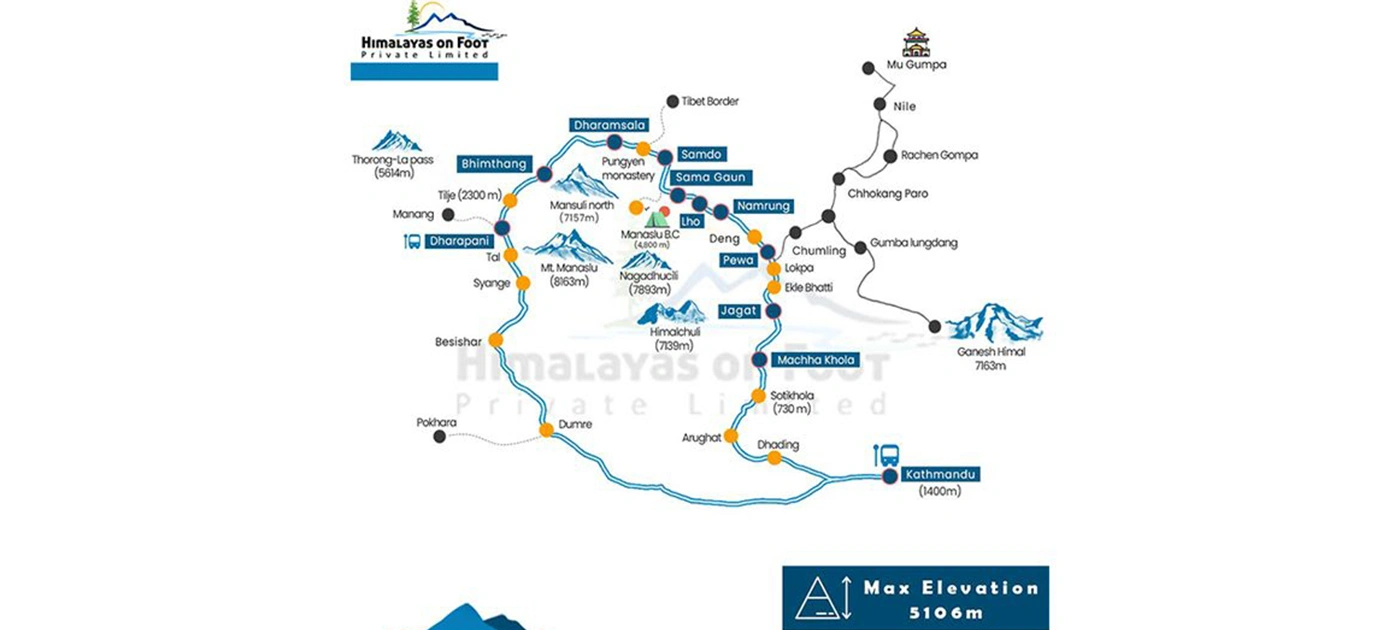
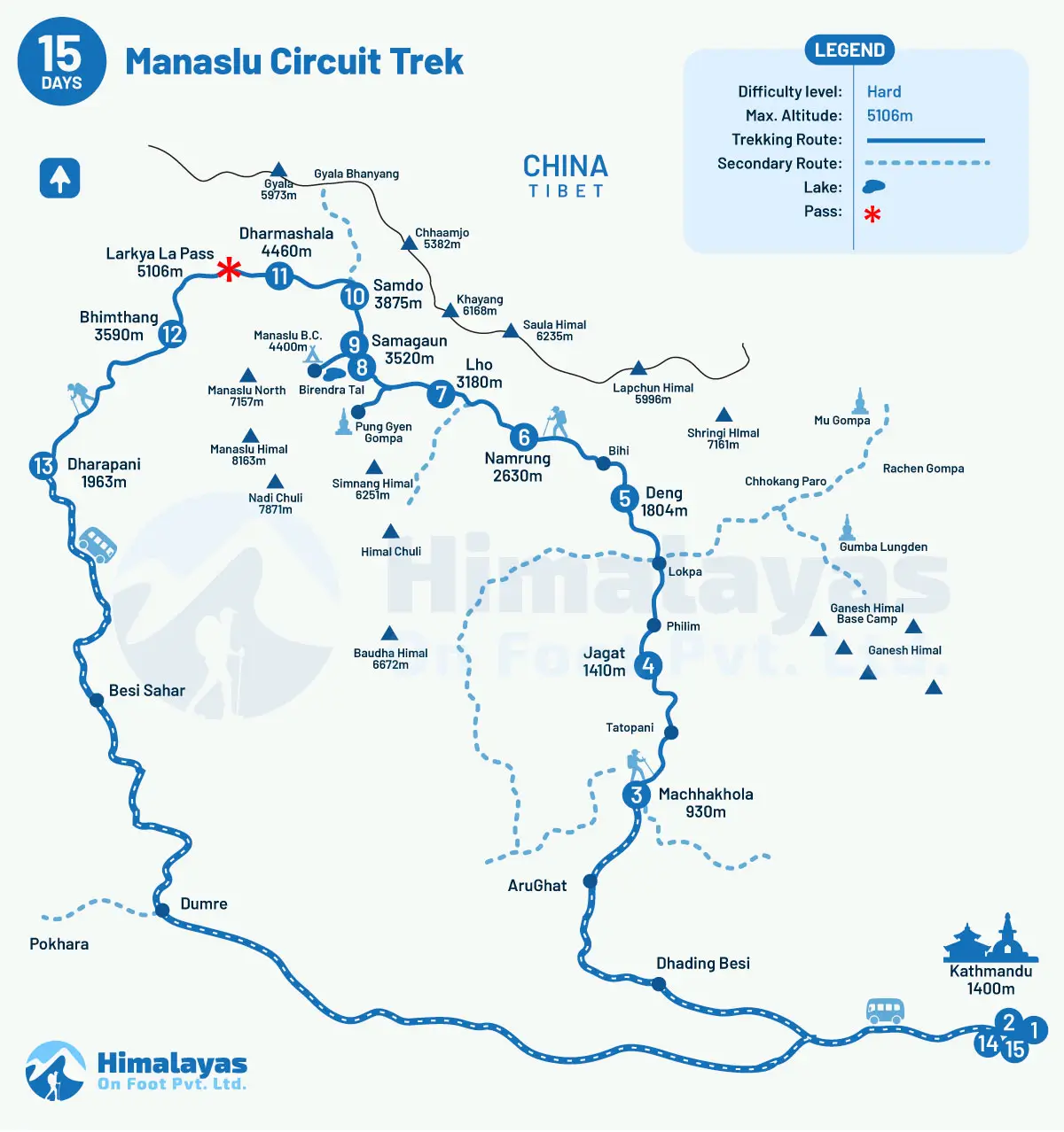
Clarity on the major trekking route: The map shows the complete trekking path from Maccha Khola to Dharapani, which greatly aids in choosing the daily hikes for trekkers, major checkpoints, teahouse locations, and also side trips.
Major highlights: The map shows key destinations such as Larke La Pass, Birendra Lake, Pung Gyen Gompa, Rachen Gompa, and Gumpa Lungden so that you do not miss the place of your dreams.
Elevation Information: It highlights the altitude of major villages, camps, and mountain passes so you can manage the altitude properly. Balance the pace as per the daily walk involved and prevent altitude sickness with a proper acclimatization plan.
Safety features: The Manaslu Circuit Trekking Map includes important details like alternative routes and emergency exits about the changing weather and its wrath that is most often difficult to say it is going to be exactly like this.
Weather Awareness: Likewise, the map also shows different climate zones, helping trekkers to set their expectations realistically on the weather on the terrain you are walking through and also dress accordingly.
Understanding the Manaslu Circuit trail map for Trekkers
As per the 15 days for the Manaslu Circuit Trekking Itinerary handpicked by the seasoned mountain guides led by Surendra Lamichhane with more than two decades of experience in Nepal tours, treks, and expeditions, Maccha Khola is the official trek starting point. Thereafter, you trek through or stay at several villages in between the trails before and after crossing the Larke La Pass, where the Manaslu Trek route map clearly marks the major villages.
Jagat, Deng, Namrung, Lho, Samagaun, Samdo, Dharamsala, Bimthang, and Dharapani. You follow the trekking trail that most of the time goes along the Budhi Gandaki River, and the Trekking Map for the Manaslu Circuit mentions this, which helps you understand the river crossings, suspension bridges, and valley terrain. Likewise, a right map includes an elevation profile for a better approach to the Larkya La Pass and later on the existing point.
Major Permit Checkpoints on the Route
Despite its opening for tourism in 1991, the Manaslu Conservation Area that the Manaslu Circuit Trekking route is a part of remains one of the most highly restricted regions where tourism is controlled, allowing only a limited number of visitors each year with a mandatory special restricted area permit (RAP), other than the Manaslu Conservation Area Permit (MCAP) and the Annapurna Conservation Area (ACAP), for gradually descending to the Annapurna region.
The price of RAP, unlike that of others, varies from one trekking season to another and is inspected at various locations throughout the journey, also called checkpoints that the Manaslu Circuit Trekking Map often mentions and are:
Jagat (1,340 m)
Philim (1,340 m)
Namrung (2,630 m)
Sama Gaun (3,530 m)
Samdo (3,860 m)
Dharapani (1,860 m)
Manaslu Circuit Trek Map with Distance
While the exact distance and duration of the Manaslu Circuit Hiking still can vary greatly based on the specific route chosen, side hikes, and whether you plan to extend the Himalayan trip all the way to the Annapurna region and cultural destinations like Nar Phu and Tsum Valley, as per the 15 days Manaslu Circuit Trek package beginning at Machha Khola and ending at Dharapani, trekkers usually cover around 177 km/110 miles, with maps giving rough ideas on daily walks:
Day
Route Segment
Distance
Trekking Hours
4
Trek from Machha Khola to Jagat
22 km/14 miles
7- 8 hours
5
Trek to Jagat from Deng
23.5 km / 14.5 miles
7- 8 hours
6
Trek from Deng to Namrung
20 km / 12 miles
7- 8 hours
7
Trek from Namrung to Lho
10 km/6.2 miles
3 - 4 hours
8
Trek from Lho to Samagaun
8 km/5 miles
3 - 4 hours
9
Acclimatization day at Samagaun (side hike to the Manaslu Base Camp or Birendra Taal)
13.5 km/5–6 km round trip
6 - 7 hours/2 - 3 hours
10
Trek from Samagaun to Samdo
8.5 km/5.28 miles
4 - 5 hours
11
Trek from Samdo to Dharamsala
9 km
4 - 5 hours
12
Dharamsala to Bimthang via Larke La Pass
16 km
8 - 9 hours
13
Trek from Bimthang to Dharapani
21 km / 13 miles
7 hours
Does the Manaslu Trek Route Map show elevation and altitude points?
Yes, it does, especially when in the Himalayas; high altitude is one of the major factors that decides how the journey is going to be, including on the Manaslu Circuit Trekking Trail. Starting the climb at 930 m above sea level at Machha Khola to reaching the highest point at around 5,106 m at Larke La Pass, the elevation gain is significant. On rapid ascent, anyone, regardless of their age, fitness level, and experience, can suffer from the symptoms of altitude sickness.
If not addressed on time, it can lead to fatal conditions like HACE and HAPE that require immediate medical attention, which is almost nonexistent, while proper acclimatization can help prevent them even before the signs appear. Therefore, it is advisable that you stick to the golden rule of hiking up and sleeping low whenever possible, while the Map for the Manaslu Trek helps you plan the acclimatization day at the right location before the significant altitude gain day.
The standard Manaslu Circuit Trek Map from the Himalayas On Foot
Safety and Navigation Tips Using the Map with Side Trips and Detours
Besides the great side trips often visited as part of the acclimatisation days, such as the Birendra Lake, Kal Tal “Death Lake", Hinang Gompa, Manaslu Base Camp, Rui La near the Tibetan border, and others, the Manaslu Circuit Trekking map often also provides details of the alternative routes to follow in case the main route is disrupted for any reason. Especially when the preparation guide for the Manaslu Circuit Hike suggests keeping plan B ready.
The trip to the Himalayas is heavily weather dependent, which can differ from morning to evening, with clear skies and warm to cold and windy in a single day. The chances of floods and landslides in the lower region, especially during the summer (monsoon) seasons, are followed by avalanches in and around the Larke La Pass. You will not regret knowing the other alternatives and major landmarks for a more immersive experience, including for 2026 and 2027.
Digital Maps vs. Paper Maps for the Trek: Which is best?
No wonder digital maps are more practical and detailed than paper maps. Accessible on a phone, it can not only zoom closer to the trails and terrain but also provide data information on distance covered, duration, and speed. However, when electricity is things of luxury in the Himalayas, and battries can run out fast, a printed offline map for Manaslu Trek becomes more convenient. Although it may not provide you with real-time location tracking, it helps you to stay on the right path.
The wisest thing to do is carry both of them. Download a digital offline map for the Manaslu Trek, so you do not have to rely on mobile data while it still provides GPS positioning and can be used even during the days with poor visibility for a quick reference. While paper maps, though, may not give you much detail with route recording and audio tracking, they ensure you do not stray away from the main route and also make the best out of what the region has to offer.
How to Read and Interpret the trekking map in Nepal? Access up-to-date map
Reading maps is as fascinating as it helps to ease the journey while in Nepal, whether you are trekking to Everest, Annapurna, Langtang, or Manaslu. Often, the contour lines show a change in height; closely packed lines translate to steep ascents and vice versa with wide gaps. This means gentler slopes; then, there are places of interest to note: villages, lakes, or monasteries some cultural spots you may want to visit.
By learning these basics, you’ll feel more confident navigating and fully enjoying the stunning Himalayan landscape, including those in the Manaslu region that you trek to and from during the circuit trek to Mt. Manaslu. The updated maps are smoother and more enjoyable; the journey tends to be. Recommended are Robinson Holidays, Peregrine Treks, or purchasing paper maps in Kathmandu, while the one we have is also a standard one with basic route information.
Conclusion
A map is a must for the Manaslu Circuit Trek for safe travel and full enjoyment. It is one of the must-have things which have potential to turn a complicated, high-altitude, remote, and camping trekking route into a clear sequence of manageable stages. I.e., a proper map for the trek to Manaslu Circuit helps with a better understanding of the route's structure from the lower Budhi Gandaki gorge to the high villages of Nubri and Tsum Valley, such as Samagaun.
With it, you have a higher chance of making it successfully through the Larke La Pass, both the main highlight and challenge. The safest option, including carrying a printed map that our standard Manaslu Circuit Trekking package also includes, or you may also download a digital trekking map and save an offline map, is also good to confirm the current conditions with a licensed guide like Yaka Datta Simkhada and Dipak Dhungana. Contact us now.