How long is the Manaslu Circuit Trek Distance? What are the possible routes? Find your answers below.
Manaslu Circuit Trek is an exciting Himalayan venture that circles the foothills of the eighth-highest towering peak in the 8,000-meter class, Mt. Manaslu (8,163 meters). What has made this trekking region popular is the serene experience it offers to trekkers; besides being adorned by the raw Himalayan wilderness, the hidden valleys of the region have also preserved ancient cultures and traditions. This enthralling trek across the natural wonders and the ancient settlements that are perfectly in sync with the Himalayas is a soul-stirring journey that shows a different take on life. If you are here, it means that you are curious about the Manaslu Circuit Trek distance and overall itinerary plan for this exciting Himalayan odyssey.
This popular off-beaten trekking adventure in Nepal is approximately 177 km (110 miles) long. This is the duration of the standard trekking package; however, if your package does include a side excursion around the region, then the total trekking distance can reach up to 220 km (136.7 miles). Keep following the article to find out more about this remote exploration, including the total trekking distance of the alternative adventures, trekking hours, and overall itinerary plans to book your next best Himalayan trekking adventure.
Manaslu Circuit Trek Distance and Facts
| Standard Trek Duration | 13 days to 18 days |
| Difficulty Level | Moderate |
| Lowest Elevation Point | Machha Khola (870 meters) |
| Highest Elevation Point | Larke La Pass (5,160 meters) |
| Accomodation | Teahouses and Tented Camps |
| Total Trekking Distance | 177 km (110 miles) |
| Average Trekking Hour | 6 to 7 hours |
| Permits | Manaslu Conservation Area Permit, Manaslu Restricted Area Permit, Annapurna Conservation Area Permit Trekkers Information Management System (TIMS Card) |
| Trekking Guide Requirement | Mandatory |
Manaslu Circuit Trek Distance and Route Details
Distance from Kathmandu to Machha Khola
Kathmandu Altitude: 1,400 meters/ 4,593 feet
Machha Khola Altitude: 870 meters/ 2,854 feet
Altitude Gain: 530 meters/ 1,738 feet
Leaving Kathmandu Valley, you will drive on the Prithvi Highway, passing the beautiful traditional villages, high rapid rivers, and terraced farms. After arriving at Dhading Besi, you will move along the trails on the mountainside. Moving along the banks of the Budhi Gandaki River on the north side, you will also pass traditional Morder Village and Simre Village before reaching Soti Khola.
From Soti Khola, you will continue driving across Lapubesi Village and cross the Nauli Khola to reach Machha Khola. You will cover a total driving distance of approximately 160 km (99 miles) on this, and your drive will last about 7 to 8 hours.
Distance from Machha Khola to Jagat
Machha Khola Altitude: 870 meters/ 2,854 feet
Jagat Altitude: 1,290 meters/ 4,232 feet
Altitude Gain: 420 meters/ 1,377 feet
You will commence the trekking part of your journey on this day, after breakfast, you will leave Machha Khola behind and trek alongside the bank of Budhi Gandaki River to reach Khorlabesi Village. You will trek on the eastern bank of the river and trek past several traditional settlements like Dobhan, Thulo Dhunga, and Yara Bagar.
During the last stretch, you will Yaru Khola River over a suspension bridge and make you ascend on the brother side of the valley to reach the Gurung village of Jagat. The Manaslu Circuit Trek distance on this day is slightly longer, and you will trek an approximate distance of 22 km (13.7 miles). It will take you about 7 to 8 hours to reach your destination after starting the trek from Machha Khola.
Distance from Jagat to Pewa
Jagat Altitude: 1,290 meters/ 4,232 feet
Pewa Altitude: 1,860 meters/ 6,102 feet
Altitude Gain: 570 meters/ 1,870 feet
Jagat is the checkpoint of the Manaslu Conservation Area, after getting your permit checked here, you will first cross Salleri Village and Sirdibas Village. Moving along the enthralling trails to the north, you will pass the terraced farms and pine and rhododendron forests heading toward your destination.
Along the way, you will also trek past another Gurung village, Philim. You will take your lunch break at Philim; then, you will cross Siyar Khola across a suspension bridge and move along the inclining route to reach the Pewa Village. The total trekking distance on this day’s trek is around 20 km (12.42 miles), and it will take about 7 hours for you to reach Pewa from Jagat.
Distance from Pewa to Namrung
Pewa Altitude: 1,860 meters/ 6,102 feet
Namrung Altitude: 2,630 meters/ 8,628 feet
Altitude Gain: 770 meters/ 2,526 feet
After breakfast you will leave the Pewa Village, following the winding up trail to the Deng Village during the first stretch. Ascending from the Tom Khola, you will then head toward Longa Chuta and join the lush forested trails of rhododendrons and fir. You will then trek on the north side of the Budhi Gandaki River to reach Bihi Phedi.
You will then continue trekking toward the Ghap Village and cross the Budhi Gandaki River again to reach the Namrung Village. This day’s trekking distance is around 19.5 km (12.11 miles), and it will take you about 6 hours to reach Namrung from Pewa.
Distance from Namrung to Lho
Namrung Altitude: 2,630 meters/ 8,628 feet
Lho Altitude: 3,180 meters/ 10,433 feet
Altitude Gain: 550 meters/ 1,804 feet
Moving further in your thrilling trekking route, you will trek on a leveled path to reach the Banjam Village. Then, trekking on the vertical trail for about one and a half hours, you will arrive at the traditional Lihi Village. As you more forward in your trekking route, you will cross a mountain stream, Hinan River, draining the Lindanda Glacier to reach the Sho Village.
A short trek from Sho on the ascending trails will then take you to the Lho Village, your resting destination on this day. The total trekking distance you will cover on this day is approximately 10 km (6.2 miles), it is a short day’s trek, and you will reach your destination in about 4 hours after starting the trek from Namrung.
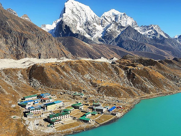
Distance from Lho to Sama Gaun
Lho Altitude: 3,180 meters/ 10,433 feet
Sama Gain Altitude: 3,500 meters/ 11,482 feet
Altitude Gain: 320 meters/ 1,049 feet
As you have to ascend to a significant altitude, the views of Manaslu and Naike Peak are captivating on this day’s trail. After enjoying your breakfast at Lho Village, you will start your trek after visiting the Lho Ribang Monastery. You will then follow the lush trails of the pine forest to reach the Shyala Village.
Then, trekking on the spiritual trail decorated with praying flags, mani walls, and colorful chortens, you will cross another glacial stream, which originates from Punggen Glacier, and make your descent to Sama Gaun, which rests on a flat surface. You will cover a total trekking distance of 9 km (5.5 miles) on this day, and it will take you about 3 to 4 hours to reach Sama Gaun from Lho Village.
Acclimatization day at Sama Gaun and hike to Manaslu Base Camp
Sama Gain Altitude: 3,500 meters/ 11,482 feet
Manaslu Base Camp Altitude: 4,400 meters/ 14,435 feet
Altitude Gain: 900 meters/ 2,952 feet
After covering a significant Manaslu Circuit Trek distance, you will take a rest day at Sama Gaun to adapt to new altitudes. As Sama Gaun is the closest village to Manaslu Base Camp, you will also do a morning hike to base camp for an effective acclimatization procedure. You will walk for about 7 to 8 hours for a two-way journey to Manaslu Base Camp and return to Sama Gaun.
Distance from Sama Gaun to Samdo
Sama Gain Altitude: 3,500 meters/ 11,482 feet
Samdo Altitude: 3,860 meters/ 12,664 feet
Altitude Gain: 360 meters/ 1,181 feet
You will leave the Sama Gaun behind after breakfast and move along the simple trail that occasionally crosses the dry patches that resembles the desert landscapes. Yu will also trek alongside the serene pasture and cross the juniper and birch forested trail before descending down to the Budhi Gandaki River.
Crossing the river over a wooden bridge, you will ascend on the terraced hills on the opposite side of the river. After crossing the slope for about 30 minutes, you will then arrive at the Samdo Village. This day’s trek lasts approximately around 3 to 4 hours, and you will cover an overall walking distance of about 10 km (6.2 miles).
Distance from Samdo to Dharamsala/Larkya B.C.
Samdo Altitude: 3,860 meters/ 12,664 feet
Dharamsala Altitude: 4,460 meters/ 14,632 feet
Altitude Gain: 600 meters/ 1,968 feet
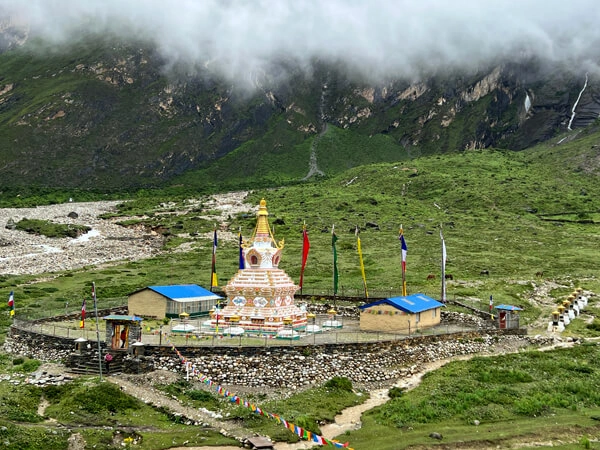
It is another short trek in the Manaslu Circuit Trek distance, after breakfast at Samdo Village, you will follow the leveled trail and slowly make your ascend to Larkya Bazaar across the barren landscape. You will then continue walking across the Himalayan stream, relishing the incredible views of Larkya Glacier and Syacha Glacier.
During the last leg, you will walk around the charming Salkha Khola Valley to reach Dharamsala. This resting destination in the Manaslu Circuit Trek route offers basic food and lodging facilities. On this day, you will trek an approximate distance of 3 km (1.86 miles), and it will take you about 3 hours to reach Dharamsala from Samdo.
Distance from Dharamsala to Bimthang via Larke La Pass
Dharamsala Altitude: 4,460 meters/ 14,632 feet
Larke Las Pass Altitude: 5,160 meters/ 16,929 feet
Bimthang Altitude: 3,720 meters/ 12,204 feet
Altitude Gain: 700 meters/ 2,296 feet
This is a challenging and thrilling day’s trek in your Manaslu Circuit Trek, today, you will cross the high Himalayan pass of the region, Larke La Pass. You will first head toward Cho Chanda and follow the steep uphill trail to reach the top of the pass. The top of this Himalayan pass will reward you with phenomenal views of Himlung Himal, Kang Guru, Annapurna II, and Cheo Himal.
You will then descend down the steep trail to reach Tabuche and trek along the pasture lands to reach Bimthang. On this day, you will cover a significant Manaslu Circuit Trek distance, walking about 18 km (11.18 miles). The journey to cross Larke La Pass from Dharamsala to reach Bimthang will take approximately 7 to 8 hours.
Distance from Bimthang to Dharapani
Bimthang Altitude: 3,720 meters/ 12,204 feet
Dharapani Altitude: 1,963 meters/ 6,440 feet
Altitude Loss: 1,757 meters/ 5,764 feet
After completing the circular journey of the world’s eight-highest peaks, you switch to the descending from this day onward. Following the changing trails across the rhododendron forests, you will make your descent to Dudh Khola and Soti Khola. Crossing Khare, a cultivated area in the valley, you will continue walking toward the Gho Village.
Then, after reaching the terraced farm level in the trekking trail, you will walk on the north side of the Dudh Khola to reach Tilje Village, a large Gurung settlement. Leaving the village through Kani, you will cross a stream to reach Thonje Village. You will cross the Marsyangdhi River over a suspension bridge from Thonje to reach Dharapani.
The total trekking distance on this day is approximately around 21 km (13.4 miles), and it will take you about 7 hours to complete this day’s descending journey.
Day 13: Distance from Dharapani to Besisahar to Kathmandu
Dharapani Altitude: 1,963 meters/ 6,440 feet
Besisahar Altitude: 820 meters/ 2,690 feet
Altitude Loss: 1,143 meters/ 3,750 feet
After completing your journey on the mountain, you will return back to Kathmandu on this day. You will first drive from Dharapni to Besishar, passing traditional settlements moving alongside the Marsyangdhi River. Joining the paved road of Prithvi Highway, you will then drive back to Kathmandu enjoying the lush scenery at the bank of the Trishuli River.
The total driving distance on this day is approximately around 243 km (150 miles) and it will take you about 7 to 8 hours to reach Kathmandu from Dharapani.
Extended Trip With Tsum Valley
If you are looking for an extended trip that dives deep into the core of the Manaslu region, the Manaslu Circuit and Tsum Valley Trek is another incredible trekking prospect in this remote region. This mystical valley that has preserved the ancient Tibetan culture and traditions is also known for its unparalleled natural beauty that bound the trekkers with its raw wilderness. As the majority of the population here follows the Buddhist religion, animal violence is non-existent here that’s why the Tsum Valley is also known as the ‘Valley of Peace and Happiness’.
The total trekking distance of the Manaslu Circuit with Tsum Valley Trek is approximately 220 km (136.7 miles). If you don’t want an extended trip with the circuit trek, you can also do just the Tsum Valley Trek. Here is what your overall itinerary plan will look like on an extended trip with Tsum Valley.
Extended Trip With Tsum Valley Outline Itinerary
Day 01: Drive from Kathmandu (1,400 meters) to Machha Khola (870 meters): 7-8 hours
Day 02: Trek from Machha Khola to Jagat (1,290 meters): 7-8 hours
Day 03: Jagat to Lokpa (2,240 meters) trekking: 6 hours
Day 04: Trek from Lokpa to Chumling (2,386 meters): 6 hours
Day 05: Chumling to Chhekampar (3,031 meters): 5-6 hours
Day 06: Trekking from Chekampar to Nile (3,361 meters): 5-6 hours
Day 07: Rest day at Nile, hike to Mu Gompa (3,700 meters): 3 hours
Day 08: Trek from Nile to Chhekampar (3,031 meters): 6 hours
Day 09: Trek back to Chumling (2,386 meters) from Chhekampar: 6-7 hours
Day 10: Chumling to Philim (1,570 meters) trek: 6-7 hours
Day 11: Trek down to Machha Khola (870 meters) from Philim: 6-7 hours
Day 12: Drive back to Kathmandu (1,400 meters) from Machha Khola: 7-8 hours
Note: If you are just doing the Tsum Valley trek, you will follow this itinerary plan, where you will move ahead on the trail of Tsum Valley from Chumling and make your return to Chumling before descending down to Machha Khola via Philim. In case if you are also doing the extended trip to Manaslu Circuit and Tsum Valley Trek, then you will join the trekking trail to Deng from Chumling and move along with the circuit route.
How Difficult is Manaslu Circuit Trek?
Manaslu Circuit Trek is the most popular off-beaten Himalayan trek in Nepal. Despite the trails of this exciting trek exploring the remote and isolated part of the west-central Himalayas, this adventure is still considered a moderately difficult trek. There are no technical sections in the route, even if you have to cross a Himalayan pass in this trek, and trekking experience in not mandatory to take part in this Himalayan odyssey.
However, the Manaslu Circuit Trek distance, altitude gain, remoteness, high altitude climatic conditions, etc, are some obstacles that trekkers have to overcome during their journey. The altitude gain can be of significant challenge as it is directly related to Acute Mountain Sickness (AMS). You will get started on the trails of this circuit trek from Machha Khola (870 meters); moving along with the gradually inclining trails, you will cross several high-altitude points like Manaslu Base Camp (4,400 meters), Samdo (3,860 meters), Dharamsala (4,460 meters) and reach the highest point at Larke Las Pass Altitude (5,160 meters).
So, without proper acclimatization, the risk of altitude sickness is high at such elevation points. Similarly, the overall Manaslu Circuit Trek distance is 177 km (110 miles); you will need to walk about 6 to 7 hours per day on average while moving along with the itinerary plans of this circuit trek. Without proper physical preparation it is not possible to cover such distance with ease carrying your luggage. The remoteness of this isolated trekking region and unpredictable weather conditions at high altitudes are other challenging aspects of the trip that the trekkers have to prepare for.
Best Time For Manaslu Circuit Trek
Understanding the Manaslu Circuit Trek distance isn’t enough if you want to ensure a safe and comfortable trekking experience. For the best experience, you should aim your adventure for the season when the trails are well-maintained, dry, and the temperatures are pleasant to support the outdoor exploration. High seasons like spring (March to May) and autumn (September to November) are known to be the most suitable climatic conditions that will substantially deduct the weather challenge from your adventure.
On the contrary, the off-seasons, like monsoon (June to August) and winter (December to February), present their own set of challenges to trekkers. During the monsoon season, the trekking trails are mostly muddy and quite be quite slipper due to continuous rainfall. Monsoon also has very unstable weather conditions, and it can majorly affect your itinerary plan. As for the winter, due to snow-covered trails, trekkers have to put extra effort into covering even short Manaslu Circuit Trek distances. To tackle the extremely cold, the heavy layers of clothes and gear will be extra baggage to bear.
So, if you want to make your journey memorable, you should go for one of the high seasons. The spring season attracts trekkers with its enchanting natural scenery, and it is also the most appropriate period if you want to explore the wildlife and birdlife of the region. Autumn, slightly different from the spring season, has the perfect climatic conditions; it hardly rains in this season, and the foliage of fall seasons shows a different side of the Himalayas.
Both high seasons also have fascinating cultural prospects that add magic to the trekking experience. Spring is generally known to celebrate unique and vibrant festivals like Maha Shivaratri, Holi, Chaitra Dahsain, Bisket Jatra, and Nepali New Year. Meanwhile, the celebration of the autumn season is on the grandeur side, this fall season celebrates some of the biggest festivals in the country, like Dashain, Tihar, Teej, Chhath, Indra Jatra, etc.