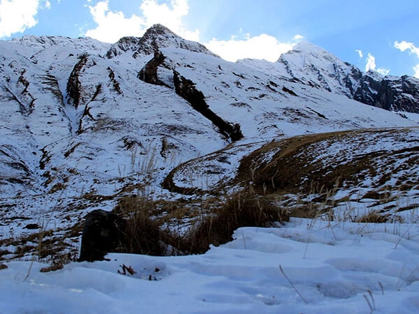
The Ama Dablam Base Camp Trek is one of Nepal’s most picturesque and rewarding treks. It is located within the Khumbu and offers great views of Ama Dablam, also known as the “Matterhorn of the Himalayas.” With its scenery and cultural richness, this trip lures many adventurers worldwide.
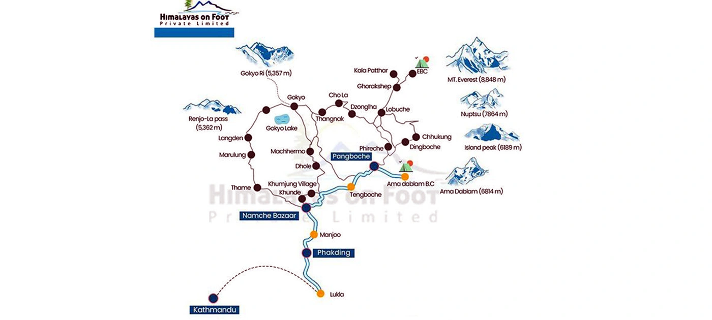
Knowing your route is very important to ensure a smooth and safe journey. A map helps you understand the route in detail, including distances, elevation gain, and any challenges that may lie ahead. Thus, you can make a very realistic schedule, allowing time for acclimatization and keeping you safe at variable altitudes. The map also highlights key landmarks to guide you and enhance your experience.
A good map includes important details like elevation profiles, landmarks, and trek distances. You’ll pass places like Namche Bazaar, which is perfect for resting and acclimatizing, and Pangboche village, which is close to the base camp at 4,600 meters (15,092 feet). This map helps to give a proper idea of elevation gain, thus preparing the person psychologically for the physical effort required, hence reducing the risk of altitude sickness.
In other words, it is more than understanding the route to Ama Dablam. It is about arriving at a destination. It is about how to make the trek much safer, more enjoyable, and more rewarding. You will then be prepared to make this highly breathtaking trek in Nepal.
Key Highlights of the Ama Dablam Base Camp Trek Route Map
- The trek begins with a stunning 35-minute flight from Kathmandu to Lukla, located at 2,840 meters and is the entrance to the Everest region.
- Some major stops include Phakding, Namche Bazaar, Tengboche and Ama Dablam Base Camp.
- These stops offer a peaceful spot to acclimatize to the altitude with breathtaking views of the highest peaks and are a highlight of the trek.
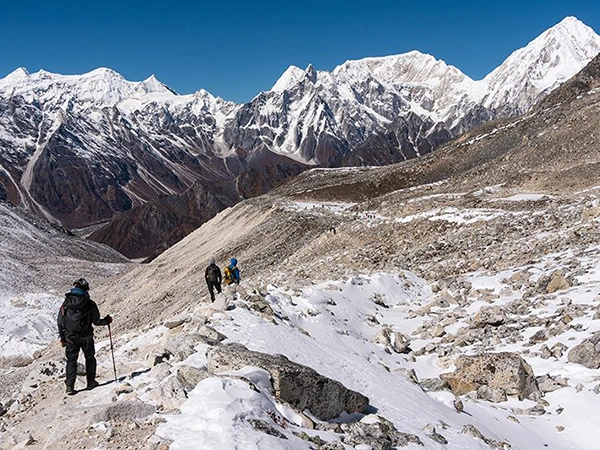
- The route consists of a gradual elevation gain with a steady climb making for easy acclimatization. Starting from Lukla, the trekkers will pass through forests and villages.
- The altitude insight is to spend time in places like Namche Bazaar to help one get acclimatized to the altitude that reduce the risks of altitude sickness before heading higher.
- You can choose a thrilling helicopter ride back to Ama Dablam Base Camp, the trek’s final stop. This option gives you an incredible aerial view of the stunning landscape, making it a memorable way to end your journey.
Ama Dablam Base Camp Trek Map and Itinerary
Things to Know About the Ama Dablam Trek Route
Ama Dablam Base Camp Trek is the varied nature of the trails, which also keeps the trek exciting and challenging. One will walk on flat, steep, and rocky trails near the base camp area. The beautiful rhododendrons and pine forests make it even more worthwhile. Crossing suspension bridges will add to the thrill while the rugged paths near base camp require careful steps.
The trek’s main highlight is Ama Dablam Base Camp is located at an elevation of 4,570m or 15,000ft. The high altitude makes proper acclimatization very important. Stops like Namche Bazaar at 3,440m high giving you time to adjust to the thinner air. Optional hikes at Namche can help your body adapt better.
To tackle the trail which is study a trek map before starting. A guide or detailed map ensures you stay on the right path, especially in tricky areas. With preparation and determination, this trek offers breathtaking views and unforgettable memories.
Trekking Distances and Hours
It takes approximately 11 days, with daily walking distances and hours dependent on the route. Here’s what the journey looks like:
- Day 1: Arrival in Kathmandu at an elevation of 1,400m. Settle in and explore the lively city.
- Day 2: Take a flight to Lukla at an elevation of 2,840m. It can then start trekking to Phakding at an altitude of 2,610m. This is a 3 to 4-hour walk through beautiful trails.
- Day 3: Walk from Phakding to Namche Bazaar at an elevation of 3,440m. The trek usually takes from 5 to 6 hours. But with amazing views and exciting suspension bridges.
- Day 4: Acclimatization day in Namche Bazaar. You can take an optional 4-5-hour hike or rest.
- Day 5: Trek to Pangboche (3,930m), another 5-6 hour walk through serene mountain landscapes.
- Day 6: Walk to Ama Dablam Base Camp at 4,570m. You can then return to Pangboche. This awe-inspiring journey takes about 5 to 6 hours.
- Day 7: Walk back to Namche Bazaar. This 5-6 hour trek will take you through the same, yet always pretty, trails.
- Day 8: Trek to Lukla. This 6 to 7 hours journey is the last of your walking adventure.
- Day 9: Fly back to Kathmandu in just 45 minutes and enjoy the view from above.
- Day 10: Discover the cultural and historical heritage of Kathmandu.
- Day 11: Farewell to Nepal with a departure from Kathmandu.
Essential Stops and Attractions Along the Route
Namche Bazaar
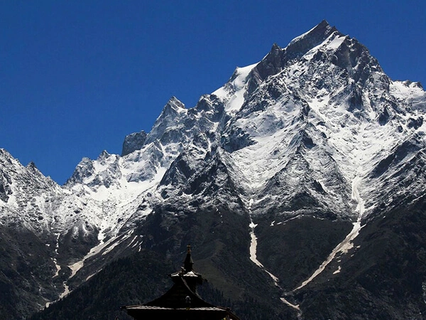
Namche Bazaar is a lively Sherpa town. It has an essential stop during the Ama Dablam trek. It sits at 3,440m, offering stunning views of Everest and Ama Dablam. Namche is considered the gateway to the Everest region. It’s a perfect place to relax and adjust to the altitude. You’ll enjoy cozy lodges, bustling cafes, and shops with trekking gear and souvenirs. The town is deeply influenced by Sherpa culture. Visiting the local museum and interacting with residents gives you a glimpse into their unique traditions. An optional hike to nearby viewpoints enhances your experience, making Namche a memorable part of your journey.
Tengboche Monastery
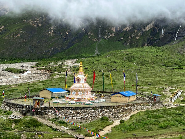
Tengboche Monastery is a spiritual and scenic gem on the trek, perched at 3,867 m above sea level. It offers clear views of Himalayan peaks, including Everest and Ama Dablam. This sacred place is one of the biggest monasteries in the Khumbu region and an important cultural hotbed. Visitors can usually witness prayer ceremonies or explore quiet surroundings. Remember to respect the monastery’s traditions, take your shoes off, and keep quiet. Nearby, you have spots ideal for the beauty of the mountains to be digested. The time spent in Tengboche links with this trek’s spiritual heart and inspires one inspired by the tranquility of this place.
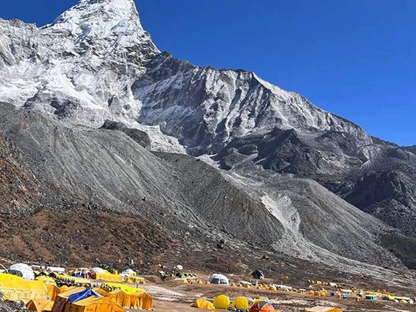
Ama Dablam Base Camp
Reaching Ama Dablam Base Camp at 4,570m is the high spot of this trek. A sensational close-up view of the iconic Ama Dablam peak is at the base camp. It is also locally referred to as “Mother’s Necklace.” It overwhelms anyone who has taken to photography or seeks serene surroundings. Timing your visit is paramount; the best conditions usually are in spring and autumn when the weather is clear. The journey to the base camp is tough, but it feels very rewarding. Standing at the foot of Ama Dablam is an unforgettable experience that crowns your trekking adventure.
Essential Stops and Attractions Along the Route
Namche Bazaar
Namche Bazaar is a lively Sherpa town. It has an essential stop during the Ama Dablam trek. It sits at 3,440m, offering stunning views of Everest and Ama Dablam. Namche is considered the gateway to the Everest region. It’s a perfect place to relax and adjust to the altitude. You’ll enjoy cozy lodges, bustling cafes, and shops with trekking gear and souvenirs. The town is deeply influenced by Sherpa culture. Visiting the local museum and interacting with residents gives you a glimpse into their unique traditions. An optional hike to nearby viewpoints enhances your experience, making Namche a memorable part of your journey.
Tengboche Monastery
Tengboche Monastery is a spiritual and scenic gem on the trek, perched at 3,867 m above sea level. It offers clear views of Himalayan peaks, including Everest and Ama Dablam. This sacred place is one of the biggest monasteries in the Khumbu region and an important cultural hotbed. Visitors can usually witness prayer ceremonies or explore quiet surroundings. Remember to respect the monastery’s traditions, take your shoes off, and keep quiet. Nearby, you have spots ideal for the beauty of the mountains to be digested. The time spent in Tengboche links with this trek’s spiritual heart and inspires one inspired by the tranquility of this place.
Ama Dablam Base Camp
Reaching Ama Dablam Base Camp at 4,570m is the high spot of this trek. A sensational close-up view of the iconic Ama Dablam peak is at the base camp. It is also locally referred to as “Mother’s Necklace.” It overwhelms anyone who has taken to photography or seeks serene surroundings. Timing your visit is paramount; the best conditions usually are in spring and autumn when the weather is clear. The journey to the base camp is tough, but it feels very rewarding. Standing at the foot of Ama Dablam is an unforgettable experience that crowns your trekking adventure.
Tips for Using the Ama Dablam Trek Route Map
Trekking in Ama Dablam is exciting, but using the route map wisely makes it more memorable. Here are some simple tips to help you use the Ama Dablam Trek route map:
Learn Symbols and Markings
Start by checking the map key to understand trail markers. It shows significant features such as junctions, lodges, and water sources. This will help you plan your route and find what you seek.
- Elevation Changes: Note the elevation change and distances between stops so that you can pace yourself accordingly and manage your energy in climbing.
Plan for Acclimatization Days
- Mark Acclimatization Stops: The places to be underlined on your map are Namche Bazaar and Tengboche. These stops are crucial for acclimatization at altitude and preventing AMS.
- Optional Side Hikes: Check around for some side hikes from Namche Bazaar. The hikes around make for good altitude adaptation and offer stunning views.
Emphasizing Main Landmarks and Points of Emergency
- Health Posts: Observe the locations of the health posts. These would be useful in case anyone has a medical problem.
- Emergency Evacuation Points: The points for emergency evacuation should be identified. Knowing the location of the helicopter landing zones may be a lifesaver during an emergency.
Safe Trekking with the Route Map
Trekking in Ama Dablam is exciting, but safety always precedes. The following are simple hints for using your route map to stay safe and enjoy your journey.
Why Hiring a Guide Enhances Safety?
- Local Knowledge: A guide’s knowledge helps them navigate tricky junctions and prevent confusion along the trail. His experience with the terrain is especially useful in more complex areas.
- Managing Challenges: Guides are also there to help with unexpected challenges. Whether it’s a sudden change in weather or an injury, they know how to assess and handle the situation quickly, ensuring your safety.
Weather and Seasonal Route Variations
- Trail Conditions: Prepare for this overview of the changing trails by season. In the monsoon, the trails might be muddy and slippery, and in winter, there may be lots of snow covering parts.
- Preparing for Diversions: If weather conditions on the main trail cause problems, be ready for a possible diversion. Your map should show different routes so you can change plans if needed.
Importance of Staying on Marked Trails
- Risks of Straying: Straying from the marked trail is dangerous. You may be assisted or encounter difficult terrain. A map keeps you on the most safe route.
- Using GPS and Apps: Bring along GPS devices or apps for trekking in addition to your physical map. These can show your location in real-time and help you stay oriented even in difficult conditions.
Getting Ready for the Ama Dablam Base Camp Trek with the Route Map
Preparing for a trek to Ama Dablam Base Camp is so exciting. However, it requires more planning while using a route map. Here are some helpful tips to help you prepare for this amazing adventure.
Packing Tips Based on the Route
Gear Essentials:
Bring in clothing that can be worn in layers: base layers that wick off moisture, mid-layers that provide warmth such as fleece, and waterproof outer layering. This will ensure you are comfortable, especially considering the changing weather conditions along the trail. Trekking poles for stability can be useful on some steep parts to support your legs while helping to reduce knee stress and make walking somewhat easier.
Snacks and Hydration Supplies:
Pack enough snacks, especially for trail sections with less access to facilities. Energy bars, nuts, and dried fruits are all excellent options. Bring enough hydration supplies, including a water bottle or bladder. Bring water purification tablets in case you need to ensure safe drinking water on the trek.
Plan Your Itinerary with the Map
Use it to guide your route. Hike 4 to 6 hours daily according to your physical aptitude. This is the speed at which most trekkers are comfortable. Insert buffer days in your schedule in case of bad weather. The weather in the mountains can be pretty unpredictable, and the buffer days give room for contingencies, especially at altitude.
Reassess Your Fitness Level
The map shows elevation changes and trail conditions, helping you assess how challenging each day will be. Note tougher sections and adjust your training before the trek. Consider adding extra acclimatization or rest days if the map highlights difficult days. This will help your body get used to higher altitudes and make the trek easier.
Conclusion: Why the Trek Route Map Is Your Best Companion
The Ama Dablam Base Camp Trek Route Map gives a big clue to anyone intent on the adventure. It makes you stay safe, plan your day, and enjoy your journey fully.
The map correctly illustrates the trail, marking landmarks, elevation changes, and stops with distances. This helps one strategize their route for the day and pace themselves for energy expenditure. Being aware of where upslope and flat paths could be expected helps you with pacing to avoid exhaustion.
This map highlights important safety spots, including health posts and evacuation zones. These are helpful in emergencies, such as altitude sickness or bad weather. Being familiar with these places can make the trek safer and reduce the risk of loss. On this map, you can see cultural spots such as Namche Bazaar and Tengboche Monastery. Visiting these places lets you experience Sherpa culture, adding more meaning to your trek.
Thus, the Ama Dablam Base Camp Trek Route Map is not just about getting around; it is a key to a safe and memorable trekking experience that shows you through the beauty and challenges of the Himalayas.
Frequently Asked Questions (FAQ):
Can a beginner climb Ama Dablam?
Ama Dablam is not for the novice. It is a technical climb that requires experience in rock and ice climbing. The steep sections and exposed ridges demand good climbing skills. If you’re new to climbing, gaining some experience on less technical peaks is better.
Is the Ama Dablam Base Camp worth it?
Yes, many trekkers find the Ama Dablam Base Camp Trek worth it. These great mountain views and surrounding Khumbu make it among the best memories. It is less crowded than Everest Base Camp, meaning a more peaceful adventure time with beautiful Himalayan scenery.
Is Ama Dablam higher than Everest?
No, Ama Dablam is not higher than Everest. Ama Dablam is 6,812 meters high, while Mt. Everest is 8,848 meters high. Everest is way taller compared to Ama Dablam.
What is Ama Dablam’s success rate?
The success rate for climbing Ama Dablam has been around 70-80% for well-trained climbers. However, that is dependent on weather conditions and the climber’s experience. About 1,900 climbers have reached the summit since it was first climbed in 1961.
Is Ama Dablam for beginners?
No, Ama Dablam is not for the beginners. It is a very technical climb and requires much technical experience that one should have previously acquired on less technical peaks.
How many people have died on Ama Dablam?
Since 1961, when it first climbed, about 18 climbers have died while trying to climb Ama Dablam. The mountain’s technical nature and risk of avalanches make it a dangerous climb.
Why is Ama Dablam so famous?
Due to its unique shape, Ama Dablam is also popularly called the “Matterhorn of the Himalayas.” It’s a stunning climb but hard to accomplish, making it popular with the most seasoned mountaineers. In the local culture and spiritual belief, “Ama Dablam” translates to “Mother’s Necklace.” Its stunning beauty, challenging climb, and cultural significance make Ama Dablam famous among trekkers and climbers.