The Mardi Himal Trek Map is key for the trekkers planning to negotiate the route to Mardi Himal Base Camp, the hidden pearl of the Annapurna region. A detailed trekking map helps you understand the overall trail, the locations of key stops, elevation profiles, trekking duration and the distances between each point on the journey.
A good map of the Mardi Himal Trek is essential to know how to navigate its varied and sometimes difficult track. It helps you to find out the parts of the trails that are strenuous and demanding. Prior anticipation of the challenges with the help of a map enables you to better prepare, like adjusting your pace, managing your energy levels and planning for rest stops. Above all, you will have a safer and more enjoyable trekking experience.
The Mardi Himal Trek Map is a core part of planning a perfect adventure. It helps you picture the whole tour by understanding details along the way and allows you to make better decisions at each stage. The map ensures that you are on the right track while providing full insight into the different types of terrain you will come across during the Mardi Himal Base Camp Trek.
After all, a map is not just about showing the route of the Mardi Himal Trek. It is a tool for enhancing the overall trekking experience. The Mardi Himal map lets you approach the journey with confidence by providing information on what to expect along the way. By understanding the route and preparing appropriately, you can enjoy this awe-inspiring trek with greater safety and satisfaction.
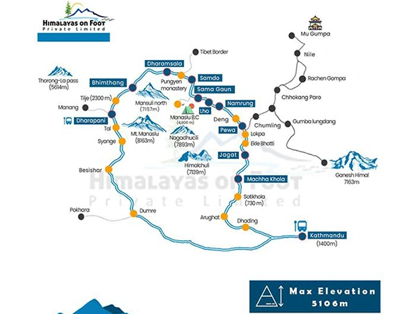
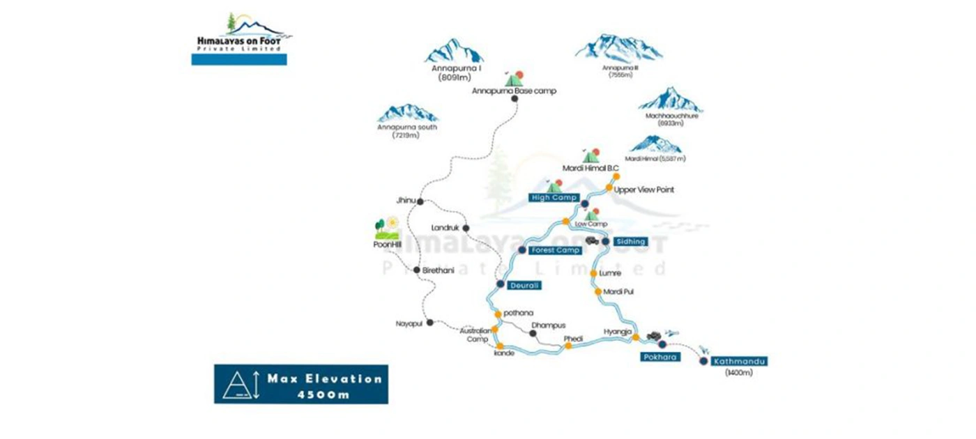
Mardi Himal Trek Route Map Overview
Our 9-day Mardi Himal Trek itinerary starts with flying to Pokhara. It is a stunning lake city located about 200 kilometers west of Kathmandu. Mardi Himal map will show the road connecting Pokhara with Kande, which is starting point of the trek. Following the Mardi Himal Base Camp Trek map, we will take a scenic drive from Pokhara to Kande.
From Kande, the trek starts and you will make a gradual ascent via small villages and rhododendron forests to Deurali. The trek continues towards Forest Camp. This section is characterized by a gentle gain in altitude while traversing the dense forests. The next destination is Badal Danda where you will walk upwards most of the time.
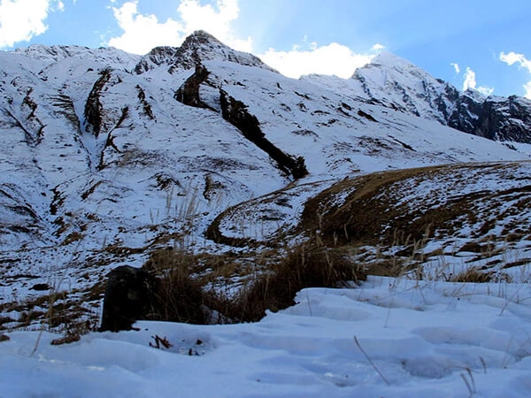
We will begin moving towards the High Camp at 3,580 meters. This part of the trek is a bit challenging due to its steep terrain and altitude gain. The map gives a good view of high-altitude features well in advance so that you can be prepared for probable rocky paths and stronger winds at this altitude. Finally, we will ascend to the Base Camp making steady climbs along rocky paths and wide alpine meadows. Here, the map elevation markers help you judge your progress and regulate your speed accordingly.
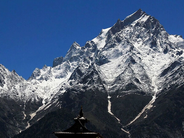
The Mardi Himal Base Camp itself, at an altitude of 4,500 meters, is marked on the map as the ultimate destination of the trek. From the Base Camp, you can enjoy panoramic views of the Annapurna range, Mardi Himal and Machapuchare. Looking at the map, you can identify other surrounding high peaks and glaciers. Once at the Base Camp, you will make your way back down to Pokhara and the map will again lead you through the route, which once again passes through the high camp and across villages like Siding and Lumre.
Uses of a Mardi Himal Base Camp Trek Map
- The altitude markers on the map during your Mardi Himal Trek let you understand the elevation changes and prepare for acclimatization.
- A map highlights the key landmarks along the way allowing you to make the most of the journey.
- A map gives insights into how the trails are up ahead and helps you prepare accordingly to navigate confidently.
- You can periodically refer to the map as you hike to make sure you are on the right track.
- Another crucial use of the map is in planning rest stops and accommodations.
- You can find various alternative routes leading to your destination with the help of maps. These optional trails may give you different perspectives and experiences of the landscape.
- In case of an emergency, a map helps you locate the nearest settlement, medical facilities, or evacuation routes so that you are prepared for anything that could go wrong.
- You can put together a guidebook or GPS app with a map to get more details on distance, elevation and the difficulty of the trail.
- The Mardi Himal Trek map with distance shows the approximate length and time required between key places and helps you plan your daily schedule.
Mardi Himal Trek Map for Understanding the Route and Scheduling the Trek
Planning the amazing Mardi Himal Trek in detail includes a complete and reliable route map. The trek weaves its way through rugged terrain with steep ascents, descents, twists and bends. Therefore, the route needs to be pretty crystal clear in your mind.
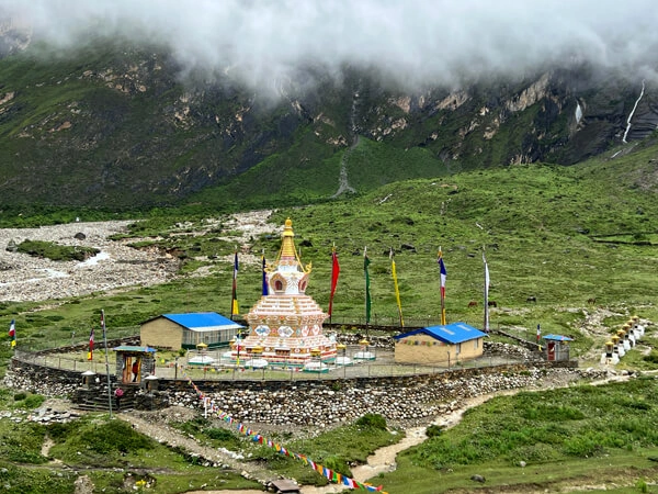
The Mardi Himal Base Camp Trek Map is an essential tool for understanding the route and planning your journey in the best possible way. A map highlights various landmarks along the way, such as villages, monasteries, viewpoints, health posts, airports, checkpoints, etc. The map also indicates natural terrains like rivers, hills, lakes, forests, mountain passes, meadows, glaciers, mountains and so on.
All these are usually marked with symbols and color codes of different shapes and sizes. This indication through a map helps you to anticipate what you will come across throughout the journey. Besides, it gives some alternative paths to reach the destination as well as emergency routes in case something unexpected occurs.
A Mardi Himal Trek map serves as an important basis on which distance and elevation gains can be estimated in order to prepare mentally and physically for the demands of a trek. With a map, you can plan a realistic schedule, taking into consideration ample time for acclimatization and safety at different altitudes.
A good, detailed and updated map is crucial for a successful trek by helping you adapt to conditions that keep changing and have better confidence in the route to be followed.
Map of Mardi Himal Trek for Acclimatization
Elevation markers on the map show an altitude profile of the trail that helps you know whether the terrain involves steep climbs, gradual ascents or vertical drops. This helps you estimate the elevation changes and identify the best spots to take rest breaks. Understanding where acclimatization stops are needed helps to schedule you accordingly and prevent altitude sickness. You can use the time to prepare for the physical challenges posed by altitude gain.
The map shows you visually how to space out the journey to allow gradual altitude gain. It indicates where you can take an extra day to acclimatize to the height. You can even look for some side hikes from your acclimatization stop for better altitude adaptation. These short hikes would be just perfect for adjusting to the thin, high altitude air while enjoying the spectacular beauty of the surrounding mountains and the landscapes.
The gradual ascent on the route, along with the sensible use of the map for pacing, means you can get up to safer heights, all the time reducing the risk that comes from quick climbing.
How to Read and Use Mardi Trek Map?
Understand the Terrain Features
The map commonly provides different terrains, such as rivers, ridges, forests, meadows and mountain passes. This helps you understand the landscape that you are going to be trekking through. Perhaps there are river crossings where the trail crosses suspension bridges or there may be rocky trails as you ascend more towards the alpine elevations. By knowing this, you will better be able to prepare yourself for what is ahead of you, often modifying your pace when necessary.
Understand the Elevation Markers
The map will include altitude markers at various points along the route. These markers indicate the elevation of key locations, such as villages, monasteries, viewpoints etc. Understanding the altitude sign gives an approximation of the elevation rises and falls you will face.
You could get where exactly the gradient of the ground is more or less steep or has extreme variations in altitude; this could provide a fair idea of how difficult any section could be. The Mardi Himal map can also be used to keep tabs on your altitude gain and assist with planning acclimatization breaks.
Identify the Main and Alternative Trail
The Mardi Himal Trek map will show the main trail you will follow which is usually marked with a line or pathway. Staying on this marked route is important to avoid getting lost or approaching unsafe areas. Use the map to get an idea of what’s ahead so you can pace yourself according to the terrain.
The map of Mardi Himal Trek also provides alternative routes to enjoy your expedition in a more broad and flexible way. On top of that, you can find emergency trails using a map which provides easy escape when the weather gets bad or something gets wrong. It highlights the closest villages, medical facilities and rescue points, ensuring you have access to an evacuation route if needed and are never far from assistance.
Distance and Time Estimates
A detailed Mardi Himal Trek map will have distance markers and estimated times between important locations. These can be helpful in giving you a sense of how much farther you have to go each day and how long it will take you to reach your next destination.
The time approximation can vary based on how fast you are going and the state of the weather. Still at least with this as your reference, you can tailor your days accordingly. You might notice, for instance, that Deurali to Forest Camp may take about 6 to 7 hours and Forest Camp to Badal Danda is 4 to 5 kilometers.
Plan Rest Stops
Having a Mardi Himal Trek route map helps you strategize rest stops. It shows villages and teahouses where you can rest, eat and stay. Use the map and identify areas where you will be able to stop for the night with decent food and comfortable accommodation. Going through a map, you can also identify an ideal point to stop for the acclimatization breaks.
Weather Changes and Seasonal Variations
Maps can give information on weather patterns or seasonal changes in trail conditions. Knowing this is important for your safety and comfort during the journey. The route may be impassable or difficult to follow at certain times of the year because of snow, rain or storms. Looking at the map for seasonal advice can influence how you plan your trek.
Anticipate how the trail condition would change according to season. During the monsoon, trails are muddy and slippery and in winter, heavy snow might cover several parts. If the conditions along the main trail don’t look good on a map, take a look for an alternate route.
You May Also Like:
- https://himalayasonfoot.com/mardi-himal-trek-difficulty/
- https://himalayasonfoot.com/best-time-to-trek-mardi-himal/
- https://himalayasonfoot.com/trip/mardi-himal-short-trek/
Perks and Drawbacks of a Digital Map
The key perks of using a digital map for the Mardi Himal trek are that it provides real-time location and helps in tracking when combined with a GPS device. This lets you stay on course and follow the right trail, especially in remote or unfamiliar areas.
Digital maps are interactive which can be zoomed in and out for a better overview of your surroundings. You can check different routes and even plan alternative paths in case of main trail closures. This flexibility is very useful in remote trekking areas of Mardi Himal with difficult terrain or topography changes. Moreover, with offline downloads on most digital map apps, you can continue to use the maps when signal reception is poor or unavailable, thus making navigation throughout the trek pretty reliable.
GPS navigation is no doubt useful and convenient but a little limiting. Being an electronic gadget, its dependence on battery power means that once the battery runs out, you could be stumbling around in search of aid. While the battery drains way too fast in the cold, remote areas like the Mardi Himal, have limited access to charging opportunities. This makes it very important to bring extra power banks or charging devices for your digital map throughout the trek.
Another setback of digital maps is they strongly depend on signal strength and data connectivity. Their performance normally declines in high altitude areas where signals are weak. At the same time, the only factor that could affect the viability of a physical map is that it could tear or be destroyed by water. Normally, this option remains a reliable means of orientation as it does not depend on battery life or signal strength.
Backups
Having some other means of navigation around is always important, either a physical map or a guide. Using a combination of both digital and traditional navigation tools provides a safer, more reliable means of trekking.
Navigating Mardi Himal Trek Route Map With Guides
Under all circumstances, hiring a guide is mandatory for adventures in the high Himalayas of Nepal. According to the recent rule of the Nepal Tourism Board, hiring a government license holder and experienced guide is a must. Here at the Himalayas on Foot, we offer trained and professional guides who not only ensure safety for your safety but are also of great help in difficult and emergency situations.
A map mainly gives you an overall idea of the entire route, but it does not provide the personal experience and expertise of a guide. As for the trail, the guide will know the whereabouts of the well known landmarks and lesser known shortcuts that may not always be evident on the map.
Likewise, the guide offers the ability to adapt to the trek in a practical manner. For instance, if sudden weather changes or when a part of the trail gets blocked by natural obstacles, guides can promptly suggest alternatives. They can make decisions on the spot regarding the prevailing conditions and will find immediate solutions. Furthermore, they also help with acclimatization knowing the right pace and places to stop to allow you to acclimate properly to the changing conditions.
General Queries on the Mardi Himal Map
What is the Map of Mardi Himal Trek?
The map of a Mardi Himal Trek is a feature-rich tool designed to guide trekkers in their mountain endeavors. This map generally depicts key points along the route, as well as the elevation, distance and duration required to travel between places.
Is the Mardi Himal Trek Map a Must to Carry?
It is advisable to have a map of Mardi Himal Trek on the journey. It helps adapt to the route, remain on track, navigate along the trail, locate key landmarks, plan rest breaks and prepare for changes in elevation.
From Where to Get the Best Mardi Himal Trek Map?
Mardi Himal maps are usually available in guidebooks and online trekking forums or can be purchased in trekking stores in Kathmandu or Pokhara. Most trekking agencies, once you book a trek with them, also provide maps. Likewise, digital maps can be generated for a real-time updates during the trek from trekking websites or GPS apps.
What to Do If I Lose My Way During the Trek?
If you lose your way and cannot find your path, you can refer to the map, orient yourself well and find the nearest known landmark. If you are not very sure, it is best to ask the locals or other trekkers. Most probably, you will get back on the right track with a good map showing clear landmarks and terrain features.
How Does the Map Contribute to Safety on the Trek?
The map plays a very important role in ensuring safety throughout the trek. It saves you from making unnecessary detours by displaying the trail clearly. It also helps you stay on track and be aware of the whereabouts of nearby villages and teahouses where you can stop over to rest and refresh.
Furthermore, the map shows distances and elevation to aid you in pacing yourself to avoid altitude sickness; besides, it indicates the health posts and clinics that allow you to reach out for medical assistance when needed.
Which Map Should I Carry for the Mardi Himal Trek, Physical or Digital?
When you are preparing to trek Mardi Himal, it is advisable to have both physical and digital maps. A physical map does not depend on batteries and can come in handy during your travels in areas where the internet is poor or nonexistent.
A digital map, on the other hand, gives you real-time location tracking and may have more information regarding the altitude. So, have the two and be ready for a well-done adventure in more remote areas where technology may fail you at times.
Can I Totally Rely on the Map or Should I Hire a Guide?
While the map is quite an important tool on your trek, the idea of hiring a guide is far better while trekking in remote and secluded Himalayan locations. Navigating some areas requires guides compulsorily; they are a good assistant in leading you through difficult and unstructured parts of the path.
They also share insights into the local culture, help with acclimatization and can identify early signs of altitude sickness, providing an added layer of security and knowledge that a map cannot provide.
How to Use Map Effectively?
Maps have different versions that can become outdated very quickly, and therefore, the latest should be part of your preparation to avoid potential issues like road blockages or newly constructed paths along the way.
Besides maps, a compass helps you find out the direction and navigate along remote and ambiguous paths. In case you encounter issues with maps or need a backup, GPS devices may be very handy. This can be quite useful if the visibility is not good or the route is not exactly clear, just perfectly guiding you to your destination with minimal effort.