The Manaslu Circuit Trek takes you on a stunning journey through one of Nepal’s least explored areas. Unlike the more popular Annapurna Circuit, it offers a unique combination of stunning nature and rich culture that attracts trekkers worldwide. The trek spans about 180 kilometers and usually takes 18 to 19 days. The trek begins with a beautiful drive from Kathmandu to Soti Khola.
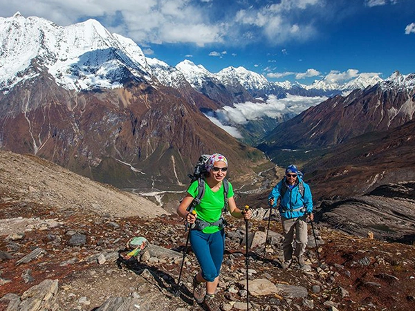
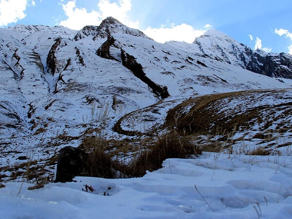
Along the way, you’ll pass through lush forests, terraced fields, and small villages, each reflecting the area’s deep cultural heritage. The trek is peaceful, far from the crowded trails. Walking through quiet villages, you’ll meet warm locals and see how they live traditionally. You’ll also enjoy amazing views of the mountains, including Mount Manaslu, the eighth-highest peak in the world.
The trek allows you to experience local culture beyond the landscapes. You can visit ancient monasteries and connect with the people, making your journey even more special. One highlight is the Larkya La Pass, where you’ll enjoy breathtaking views and feel great achievement at a high altitude. The trek offers an unforgettable adventure with stunning nature, rich culture, and a spirit of exploration. It’s ideal for anyone looking to experience Nepal’s heritage.
Here are some of the key features to keep in mind while doing Manaslu Circuit Trek:
- Always keep the map with you. It will help you stay on the right path and prevent you from getting lost.
- Check the map for distances and walking times. This helps you set real targets and avoid overexertion.
- Pay attention to the elevation points on the map. Acclimatizing properly helps prevent altitude sickness.
- The map below shows some campsites along the way. Use it to decide where to rest and recover during the trek.
- The map highlights monasteries and villages. Take the chance to experience the local culture and traditions up close.
- The map shows various climates. Pack accordingly and be prepared for any weather changes.
- Familiarize yourself with alternate routes and exits on a map for your safety.
Why You Need a Map for the Manaslu Circuit Trek?
A map is essential on your Manaslu Circuit Trek as it will guide you along steep ascents and daunting descents through varied landscapes. Without one, one is likelier to lose his way or skip a significant landmark. The trail may get tricky, especially where signs are few and far between. A good map will keep you on course, saving detours.
Detailed route planning is an important and major part of any trek. A detailed map showing the stages of the treks, altitudes reached, distances, and day walks with times allows the planning of day hikes, managing personal energy, and altitude adaptations accordingly. Knowing where the resting points or lodgings are will make many differences to your trekking adventure.
A map also introduces you to the landscape besides navigation and planning: it shows the peaks, valleys, and villages you will pass, adding to your experience. Taking a map of the Manaslu Circuit is important for both a novice trekker and an experienced hiker. It ensures safe navigation, effective planning, and a more enjoyable experience in this stunning region.
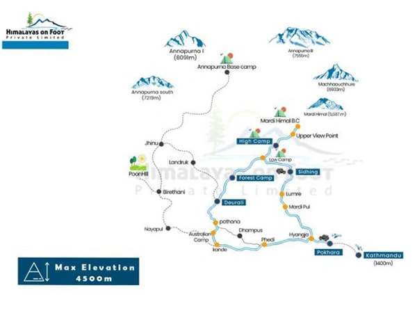
Key Features of Manaslu Circuit Trek Map
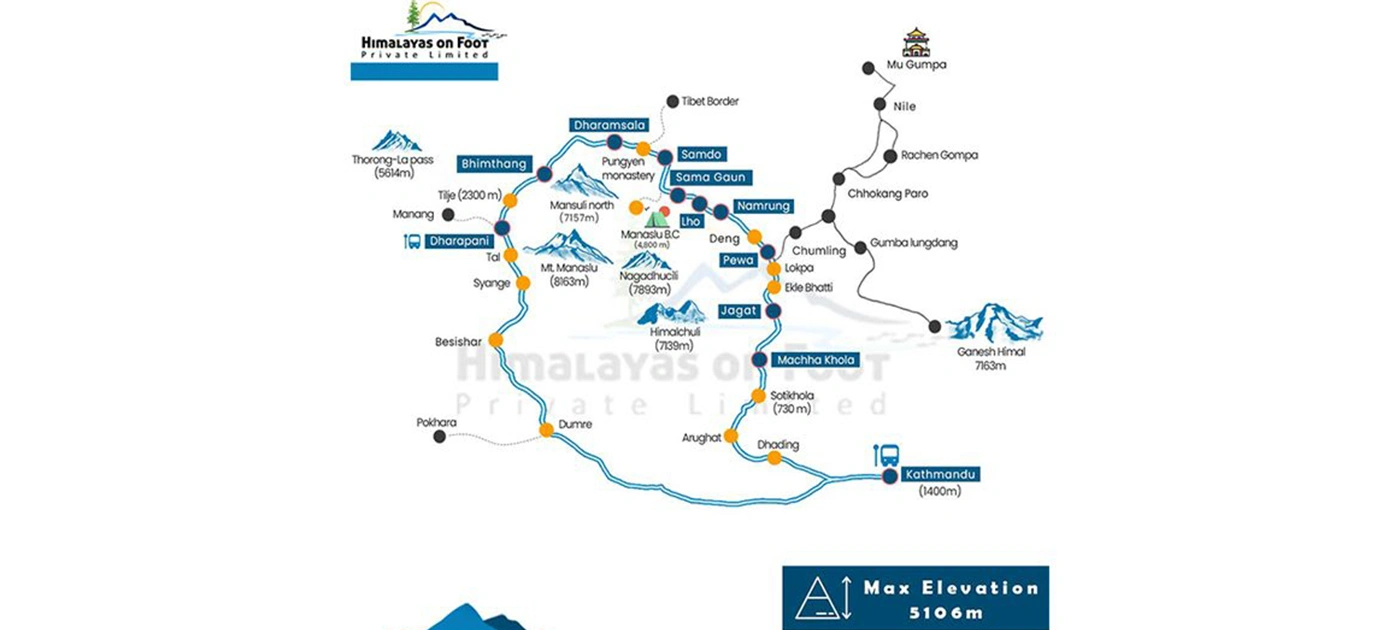
- Clear Route: The map shows the route from Soti Khola to Bimthang, making the trek path clear. This helps the trekkers in choosing their daily hikes.
- Landmarks: It marks key places like Larke La Pass and Birendra Lake, making it easier for trekkers to navigate and enjoy these important places.
- Elevation Information: The map includes elevation markers so trekkers can keep up with the gain in altitude. It will help them move at a comfortable pace to avoid altitude sickness.
- Campsites: These set campsites help to enhance planning for the overnight stay for trekkers. This ensures smooth and comfortable trekking routines.
- Cultural Insights: It highlights nearby villages and cultural attractions so trekkers can interact with the place’s culture. Experience monasteries, festivals and traditions along the way.
- Safety Features: Important details like alternative routes and emergency exits are marked. This prepares trekkers for unexpected situations.
- Weather Awareness: The map shows different climate zones, helping trekkers understand what weather to expect.
Popular Starting and Ending Points
The Manaslu Circuit Trek usually starts in Soti Khola, which takes almost six hours of drive from Kathmandu, normally by bus or hired jeep, often with great views, and takes trekkers on this trip. From Soti Khola, the actual trek starts uphill to the village of Machha Khola, which is nice.
Trekkers will cross green forests and beautiful villages to reach Bimtang, then circle the impressive Manaslu mountain. The trek ends at Dharapani, where the Manaslu and Annapurna circuits unite. You can catch a local bus from Dharapani via Besisahar and return to Kathmandu to finish the adventure. This route offers great views and a glimpse into the region’s rich culture, hence a lifetime memory for everyone.
Manaslu Restricted Area and Permits
To trek the Manaslu Circuit, it’s important to understand the permit rules and restricted areas. The Manaslu region is restricted, meaning solo trekkers can’t go alone. At least two trekkers must be with a licensed guide. This keeps trekkers safe and follows local rules. To trek in Manaslu, you need three permits. The first one is the Manaslu Restricted Area Permit (RAP). It allows access to areas from Jagat to Samagaon.
The second is the Manaslu Conservation Area Permit (MCAP). It covers the area from Philim. You will need the Annapurna Conservation Area Permit (ACAP) when trekking in the Annapurna region. These permits help keep the trek safe and protect the environment. Be sure to get them before you start your adventure.
Villages and Stops Along the Trek
The Manaslu Circuit Trek has to its credit several beautiful villages where one can rest and stay. Starting from Soti Khola, the first village is Machha Khola. It is famous for its friendly teahouses. Further ahead, you will reach Jagat, a lively village with many places to stay.
Later comes Deng, followed by Lho, which is a place that allows you to explore the magnificent Ribung Monastery and local teahouses that are full of Tibetan culture. Continuing, you come across Samagaon, the largest village on the way. It’s a great spot to relax and adjust to the altitude. Not far before Larkya La, you will find Samdo, a small village full of Tibetan culture.
Trekkers usually visit this village to learn about the customs and way of life in this part of the world. Each village along the route has places to stay, allowing visitors to experience local life and enjoy a warm welcome from the people.
Side Trips and Detours on the Manaslu Circuit
Some great side trips further enhance your adventure around the Manaslu Circuit Trek. The favorite detour includes Birendra Lake, a placid spot from where you can sit around, relax, picnic, and take snaps. Then there is Kal Tal, called “Death Lake,” featuring dark waters and promising amazing mountain scenery.
If you are interested in culture, visiting Hinang Gompa near Lho is necessary. This quiet monastery gives you a glimpse into the local Buddhist way of life, set against the towering Himalchuli. You can also head towards Manaslu Base Camp, home to unforgettable views of the mighty Manaslu peaks.
For a special experience, a journey towards Rui La near the Tibetan border must be taken up. Rare vision of this area’s cultural and historical evidence makes it a perfect route. This might be your great time spent in natural beauty and connecting to the rich heritage through these side trips.
Elevation and Altitude Points on the Map
Elevation plays a big role in the Manaslu Circuit Trek. The highest point is Larkya La Pass, standing at 5,160 meters. It offers a startling view of peaks and valleys within its vicinity. The trek begins with a gentle climb at 730 meters from Soti Khola, passing through villages such as Namrung at 2,630 meters and reaching up to Samagaon at 3,530 meters.
Acclimatization is necessary at these stops, especially approaching the altitude near Larkya La. Finally, crossing the pass, one reaches Bimthang at an elevation of 3,610 meters. The effort feels completely worth it when you see the views from here. Knowing such elevations helps you prepare for a safe and enjoyable trek.
Best Time to Use the Map for the Trek
The best time for the Manaslu Circuit Trek is spring, from March to May, or autumn, from September to November. This is when the weather for trekking is at its best, with clear skies and stability. The rhododendrons add colors to the trails during spring, making the scenery magnificent. The temperatures are moderate, with comfortable walks.
Right after the monsoon, autumn brings in fresh air and views of snow-capped mountain peaks. It feels peaceful because fewer people visit during this season. During these months, plenty of guesthouses and food are available, making the trek easy. You could also see Manaslu in full glory when trekking in spring and autumn, which offers optimum weather and conditions. That will make your adventure less problematic and more memorable.
Digital Maps vs. Paper Maps for the Trek
During the planning of the Manaslu Circuit Trek, there is an option between digital and paper maps. Digital maps are practical and detailed. It can zoom closer to trails and terrain. They are easily accessible on your smartphone, making them convenient during the trek. However, relying on only a device can be risky if the battery runs out or there’s no signal.
Paper maps require no power at all and are very reliable. They help you get oriented with the landscape, developing your navigation skills. Although they probably won’t show as much detail as digital maps, they’ll give you a clear vision of the route.
Bringing both would be the wisest. Digital maps provide quick references, while paper maps ensure you never leave your guidance behind. They guide you to stay on the right path and enjoy the trek’s beauty.
How to Read and Interpret the Map?
Reading the Manaslu Circuit Trek map makes your journey easy and fascinating. Firstly, understand contour lines showing a change in height. Closely packed lines translate to steep ascents and vice-versa with wide gaps. This means gentler slopes, making it easier for you to prepare for any challenges during the trek.
Then, there are places of interest to note: villages, lakes, or monasteries. These guide your route and highlight some cultural spots you want to visit. Check the distances shown on the map to organize your day walks better. Altitude markers are important, too. These help you track your climb and avoid altitude sickness. Keep the map close since it shows the key details about campsites and water sources. By learning these basics, you’ll feel more confident navigating and fully enjoying the stunning Manaslu landscape.
Safety and Navigation Tips Using the Map
Knowing how to read a map is key to having a safe trek on the Manaslu Circuit. Start by understanding the contour lines. These lines show elevation changes, so you’ll know where steep climbs or descents are ahead. Closely packed lines mean tougher sections so plan accordingly.
Look for landmarks like villages, rivers and peaks. These can guide you and serve as good spots to rest. Check the distances marked on your map to create a realistic plan for your daily hikes.
Be prepared for any time the weather changes in the Himalayas. Always have plans A and B concerning whether the weather is bad or when the trails are closed. Finally, take a compass and see how it works in conjunction with your map to keep you on course while you explore beautiful yet harsh landscapes with safety.
Accessing Updated Maps for the Manaslu Circuit
Updated maps make your journey smooth and enjoyable on the Manaslu Circuit Trek. First, look at some online websites that deal in trekking maps. Websites like Robinson Holidays and Peregrine Treks show clear, detailed maps prepared for the Manaslu Circuit. These maps depict campsites, landmarks, and elevation changes, making planning your trek easier.
You can also download several maps on your smartphone or tablet, which are accessible on the trail. In contrast, physical maps are probably purchased from trekking shops in Kathmandu or Pokhara for backup. These printed maps give clear details about distances and terrain, helping you navigate confidently through the area.
These tips will help you stay ready and fully enjoy the stunning beauty of the Manaslu Circuit. Maps updated assure you do not miss the key highlights and are kept on the right track throughout your adventure.
Incorporating GPS Technology with Traditional Maps
The GPS and the map will make trekking over the Manaslu Circuit much easier and safer. We at the Himalayas on Foot always recommend using modern gadgets with classic navigation for seamless adventure.
First, study a detailed paper map. Learn about the terrain, key landmarks and elevation changes to understand the route. You can use a GPS device or a smartphone app to download the trek’s route in advance. This lets you check your position quickly, especially when the view is poor.
While GPS can be very useful, always carry a paper map if your device stops working. This simple combination will let you confidently explore the beautiful Manaslu region. Mixing modern technology with traditional navigation gives you the best of both for a safe and enjoyable trekking experience.
Conclusion
A map is a must for the Manaslu Circuit Trek. It helps in safe travel and full enjoyment of the journey. You can confidently navigate through different landscapes and tricky paths with a map. Be it a beginner in trekking or an experienced one, it keeps you on track, especially in remote areas where signs are rarely found.
Maps provide information such as altitude levels, campsites, and key spots. They make it easier to plan your hikes and save your energy. You will also find cultural highlights marked that help you connect better with the local traditions. Knowing elevation points lets you prepare for altitude changes and avoid sickness.
Whether you use a paper map or an electronic one, it is always good to have the other as extra safety. Using a GPS device with your map makes things easier. The map isn’t just a guide; it’s your reliable partner on this journey. It helps you discover stunning views and the vibrant culture of the Manaslu region.
Call To Action
The Manaslu Circuit Trek is a thrilling adventure you can access from our official website of the Himalayas on Foot, and we try to make it unforgettable and enjoyable for you. We guide you through every step for your safety and enhancement in your trek. We assist in everything, from guiding your itinerary to acclimatization and equipment essentials.
Feel free to contact us if you are ready for this adventure or need more information. We’re always reachable via WhatsApp, Viber, Line, WeChat, or Imo at +977 9851018068. For further information or to book your trek, visit our contact page. We’re here around the clock to help you plan your trip. Let us guide you in exploring the breathtaking beauty of the Manaslu region.